Aotearoa Summary. 2 February 2026 - 4 March 2026
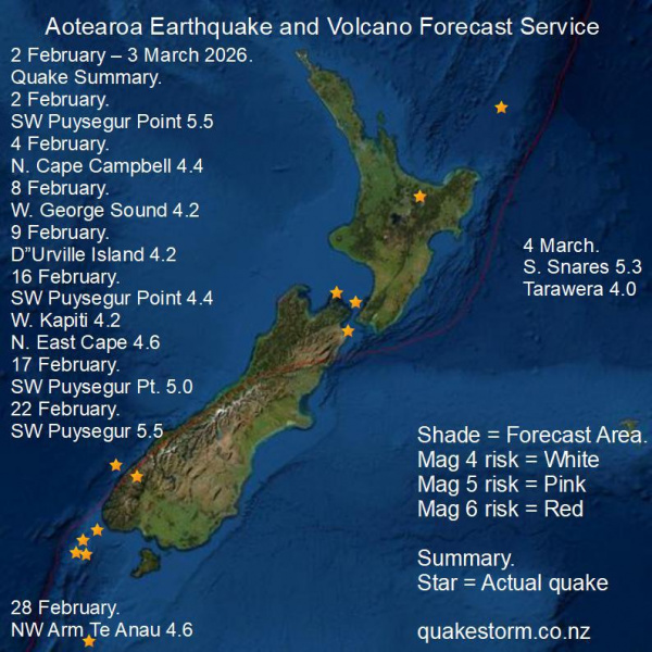
The expected strong tectonic response from the big 19 January Kp8 geomagnetic storm appears to have leaked out slowly over all of February, justifying the risk locations and magnitudes but timing was obviously an issue over such a wide time period. The simple forecast rule that quakes from risk locations during a forecast period are still likely after the period ends has been met once more. Auroras not only drive tectonic activity but also weather systems which unlike quakes respond very fast to ionospheric energy. Weather systems rapidly intensify during geomagnetic storms and Mt Maunganui and East Cape deluges came on 22 January following several days of ionospheric storming.... The following forecast period is likely to include South of Fiordland, Fiordland as Mag 5/6 risk locations. 2 February 2026. 100km SW Puysegur Point 5.5 9.15pm 4 February. 15 km N. Cape Campbell 4.4 12.35pm 8 February. 30km W. George Sound 4.2 1.09am 9 February. D"Urville Island 4.2 3.27am 16 February. 100km SW Puysegur Point 4.4 8.19pm 30km W. Kapiti 4.2 9.04pm 200km NNE East Cape 4.6 10.33am 17 February. 100km SW Puysegur Point 5.0 2.16am 22 February. Puysegur Point 5.5 12.55pm 28 February. NW Arm Te Anau 4.6 12.00am 4 March. 120km S. Snares Islands 5.3 12.54am 10km N. Tarawera 4.0 2.35am 130km depth. Aotearoa Earthquake and Volcano Forecast Service © 2013 - 2026 |