Aotearoa Summary. 1 January 2017 - 2 January 2017
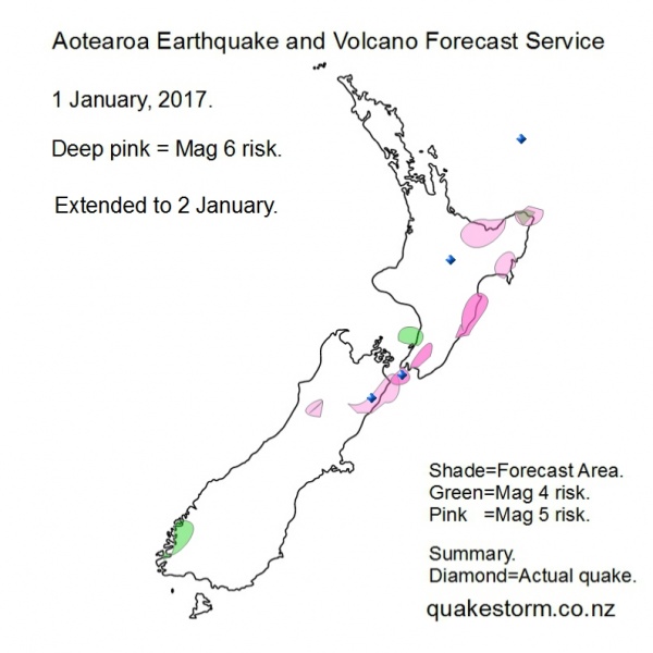
Magnitude 5 risk areas are Upper Crooked River, Culverden, Kaikoura, Offshore Kaikoura, Seaward Kaikouras, Lower Clarence, Ward, Cape Campbell, Wairoa, Gisborne, Opotiki, Northern Urewera, Murupara, Rotorua. Magnitude 4 risk areas are Fiordland, Levin, West of Levin, East Cape. A significant shift away from Kaikoura may be underway. Location confidence =low. Volcanoes quiet. Update. 1 January 11.45am East Cape, Tokoroa are added to Mag 5 risk areas. Forecast map updated. Update. 2 January 1.45pm 1 January. Northeast of Cape Campbell 4.3 11.52pm The forecast period is extended to 2 January. Moderate solar quake driving conditions arrived on time but quakes are sparse. Quakes may remain infrequent or absent. New Zealand remains a Pacific quake hotspot. Be careful. Forecast map updated. Summary. 1 January. Northeast of Cape Campbell 4.3 11.52pm 2 January. Taupo 3.8 + swarm. 10.12pm West of Kaikoura 4.6 10.47pm North of East Cape 4.6 11.17pm Quakes have come very late in the period. A push is on into the North Island. New Zealand and Kermadec Islands are the Pacific hotspot. Aotearoa Earthquake and Volcano Forecast Service © 2013 - 2026 |