Aotearoa Summary. 12 July 2017 - 14 July 2017
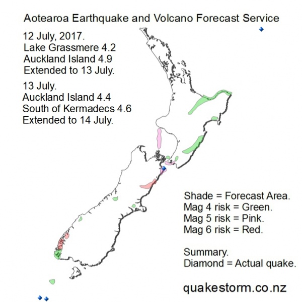
Magnitude 5 risk areas are Ward, Cape Campbell, Seddon, South of Wellington, Orongorongo Valley, Central Taranaki Bight, South of Taranaki. Magnitude 4 risk areas are Cascade River, Upper Hokitika River, Rolleston, West of Rolleston, West of Mana Island, Atiwhakatu Stream, Eketahuna, Dannevirke, Porangahau, Waipukurau, Wairoa, Taupo, Tokoroa, Rotorua, Whakatane, Opotiki, East Cape. Quakes are likely to be infrequent. High magnitude is possible. Volcanoes quiet. Be careful. Update. 12 July 1.0.30pm Lake Grassmere 4.2 3.05am Northwest of Auckland Island 4.9 7.53pm The forecast period is extended to 13 July. Quakes became infrequent on 12 July. Solar quake driving conditions are steadily weakening as the end of the forecast period approaches. Quakes seem likely to be very infrequent on 13 July but a late isolated quake is possible. High magnitude is possible. Volcanoes quiet. The forecast map bears a slight resemblance to weather maps for the same period and will keep the sceptics (and quake forecasters) guessing. A decent winter storm is crossing the country with Cook Strait/North Island forecasted to receive some big weather and easing conditions in the south. Update. 14 July 12.00am Northwest of Auckland Island 4.4 7.18am Southwest of Kermadecs 4.6 2.43pm The forecast period is extended to 14 July. Quake action north and south of New Zealand on 13 July but the mainland was quiet. Solar conditions initially faded but then steadily gained strength later and are moderate tonight. Conditions seem likely to weaken again on 14 July as the period closes. Quakes during the period are in the Southwest Pacific including New Zealand. A big local quake on 14 July is becoming unlikely but still possible. Summary. 12 July. Lake Grassmere 4.2 3.05am Northwest of Auckland Island 4.9 7.53pm 13 July. Northwest of Auckland Island 4.4 7.18am Southwest of Kermadecs 4.6 2.43pm 14 July. Northeast of East Cape 3.6 1.19am The wider 9-14 July forecast period has worked. The 11 July Northwest of Auckland Island 6.6 was not far north from the infrequently forecasted Macquarie Island area. (see Pacific Forecast) A new map was submitted on 12 July with increased magnitude risk and new locations around Cook Strait. Solar conditions were steadily easing by 13 July and quakes faded away. A very strong quake period may unfold by mid 17 July. A forecast map for the period is likely to be very similar to the present map. A major winter storm in New Zealand coincided with the quake period. Near record snow in Central North Island and much flood, wind damage. South Island is also frozen hard. Solar driven auroras make no distinction between effects above or below ground. Big storms will power up during quake periods. Aotearoa Earthquake and Volcano Forecast Service © 2013 - 2026 |