Aotearoa Summary. 21 July 2017 - 29 July 2017
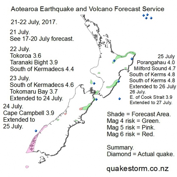
Magnitude 6 risk areas are Upper Hokitika River/Mikonui River, Culverden. Magnitude 5 risk areas are Snares Islands, Fiordland, Cascade River. Magnitude 4 risk areas are Mount Cook, Rolleston, Methven, Cheviot, Seaward Kaikouras, Kaikouras, Ward, Cape Campbell, Seddon, East of Tory Channel, South of Wellington, West of Mana Island, Central Taranaki Bight, Northeast of Hawera, Eketahuna, Dannevirke, Waipukurau, Porangahau, Wairoa, East Cape, Opotiki, Whakatane, Rotorua, Tokoroa. The 22 July quake period has arrived a day early. The quakes listed occurred before this forecast is posted. The forecast is for the remainder of the period. Data indicates more action is possible in the South Island. Weather is powered up on 21 July. A Canterbury storm with flooding and possible heavy snow is currently underway. Be careful. 21 July. Upper Hokitika River 4.3 1.39am Western Turkey/Kos 6.7 10.31am The Upper Hokitika 4.3 fits the earlier 17-19 July forecast map. Update. 23 July 11.30pm 21 July. Local and Pacific quakes lessened after the Upper Hoki 4.3 and Turkey 6.7 which arrived before a forecast was posted. 22 July. Tokoroa 3.6 3.13am Methven 2.7 9.10am Central Taranaki Bight 3.9 8.20pm South of Kermadec Islands 4.4 8.41pm 23 July. Tokomaru Bay 3.7 7.39am South of Kermadec Islands 4.6 8.40am Light quakes up to Mag 4 on 22 July accompanied very heavy rain between Christchurch, Dunedin and some inland areas. The Central Taranaki Bight 3.9 was widely felt along the Kapiti Coast and further. Solar conditions are moderate and steady on 23 July. A slow buildup is possibly underway. The forecast period is extended to 24 July. Quakes are likely to be infrequent. An isolated big quake is possible. Quakes, eruptions and weather go together. Be careful. The period is likely to be extended to 25 July and may close on 26 July. Update. 25 July 12.00am 24 July. Cape Campbell 3.9, 5.25pm; 3.6; 3.5 Motueka 3.7 11.37pm The forecast period is extended to 25 July. Quakes were just under Mag 4 on 24 July. Cape Campbell was busy. Solar conditions continued to be steady as expected. A slow buildup could still be underway. Conditions seem likely to weaken on 25 July as the forecast period slowly closes. An isolated local quake is possible. High magnitude is still possible. Update. 26 July 1.00am 25 July. South of Kermadec Islands 4.8 3.04am Opotiki 3.6 3.05am West of Rolleston 2.5 3.43am West of Milford Sound 4.7 4.20am Porangahau 4.0 10.24am Cape Campbell 3.8 2.09pm South of Kermadec Islands 4.8 7.13pm Local quakes were very busy on 25 July. Good small quake location success West of Rolleston. Mag 5 risk in Fiordland is justified after several days of quiet. Solar quake driving conditions were moderate but steady, lunar conditions were moderate on 25 July. Solar conditions have picked up strongly tonight but are likely to fade again as the forecast period closes. The forecast period is extended to 26 July. High magnitude quakes seem possible on 26 July, including Mag 6. Fiordland Low tide =7.00am 7.30pm. Be careful. 27 July 12.00am 26 July. Ward 3.6 7.07pm 100km East of Cook Strait 3.9 9.44pm Local quakes were low magnitude. Solar driving conditions remained weak but steady. Solar conditions are taking longer to fade than forecasted yesterday. The forecast is extended to 27 July. Quakes are likely to be infrequent. Mag 6 risk is maintained until the period closes, a late quake still seems possible. Mag 6 confidence=low. Update. 29 July 1.52am. Solar quake driving conditions have arrived tonight. Local quake activity is possible on 29 July. Locations are the same as the 21-27 July forecast map. An update will be posted soon. Thanks. This update was posted on Facebook/Roary Arbon but not the archive at quakestorm.co.nz. Summary. 21 July. Upper Hokitika River 4.3 1.39am 22 July. Tokoroa 3.6 3.13am Methven 2.7 9.10am Central Taranaki Bight 3.9 8.20pm South of Kermadec Islands 4.4 8.41pm 23 July. Tokomaru Bay 3.7 7.39am South of Kermadec Islands 4.6 8.40am 24 July. Cape Campbell 3.9, 5.25pm; 3.6; 3.5 Motueka 3.7 11.37pm 25 July. South of Kermadec Islands 4.8 3.04am Opotiki 3.6 3.05am West of Rolleston 2.5 3.43am West of Milford Sound 4.7 4.20am Porangahau 4.0 10.24am Cape Campbell 3.8 2.09pm South of Kermadec Islands 4.8 7.13pm 29 July. Lake Te Anau 3.7 1.09am Northwest of Auckland Island 4.4 3.31am This forecast had some timing issues along with the corresponding Pacific forecast. The outlook for the period to begin on 22 July was a timing mistake. The quake period started early on 21 July, no forecast was posted. A forecast was posted for the remainder of the period. The Upper Hokitika River 4.3 came before a forecast was posted but the location matched the previous 17-20 July forecast map. Upper Hokitika River featured in the new forecast but the location went quiet. Quakes struggled to reach Mag 4 during the period but locations were good on the biggest daily quakes. Low magnitude activity West of Rolleston continued during the period. The Offshore Milford Sound 4.7 and South of Kermadecs quakes were ominous but luckily quakes didn't get bigger onshore and Mag 6 risk wasn't justified in the end. More timing issues emerged at the end of the period. Late solar driving conditions expected on 26-27 July never showed up and the forecast went low confidence. Solar conditions then showed up two days late on 29 July, a forecast mistake. A brief update for 29 July was posted on Facebook but not on quakestorm.co.nz The update was justified with an aftershock from the 11 July Auckland Island 6.6 and Te Anau 3.7. There were significant weather events during the period. A South Island East Coast rain bomb on 21-22 July broke a few records. Very heavy monsoon rain in India came on the same day. Climate data for Greenland this year shows a heavy snow buildup and little summer melt, in direct contrast to many TV news items showing rivers of meltwater running over disappearing glaciers and alarmist global warming talk. A new quake period begins late on 2 August and could intensify weather over the North Island. Aotearoa Earthquake and Volcano Forecast Service © 2013 - 2026 |